Gaussian Splatting for Construction Progress: 360 Video and Splats
Use Gaussian splatting and 360 video for repeatable construction progress tours, remote site review, dated visual context, and stakeholder updates.
In this guide
Construction progress tours are useful when each capture has a date, repeatable route, stable zone names, controlled audience, and a clear relationship to the project's authoritative records.
Short answer
Gaussian splatting for construction progress can turn phone, 360-camera, drone, photo, or mixed capture into a navigable visual record. It helps a remote reviewer understand the site state, move between named locations, and revisit visible conditions after the capture team has left.
Keep survey, inspection, safety, schedule, cost, issue, and contractual records in their authoritative systems. AEC Magazine's review of Gaussian splats for AEC describes the same near-term fit: fast and visually rich documentation, with measured and engineering workflows retaining authority.
Spatial Studio is worth considering for the visual delivery layer. Teams can generate a splat from supported media, set stable viewpoints, add zone or issue context, publish a browser link or embed, and review engagement. The project common data environment and issue tools should keep the formal record.

Define the comparison before the capture
"Progress" can mean visual communication, installed quantities, schedule status, payment evidence, quality inspection, or as-built geometry. A tour cannot safely answer all of those questions by itself.
| Need | What the tour can show | What must remain authoritative elsewhere |
|---|---|---|
| Remote familiarization | Overall site state, access, sequence, and visible context | Site briefing, safety plan, and current instructions |
| Visual progress update | Dated views of named areas | Approved schedule, quantities, and commercial status |
| Issue context | Where a visible condition sits in the space | Owned issue, assignee, decision, and closure evidence |
| Design comparison | Visual relationship between capture and intended work | Controlled BIM, drawings, registration, and approval |
| Handover or marketing | Curated route through completed or public areas | Asset data, warranties, compliance, and client records |
Write the intended question at the top of the capture brief. If the answer requires a dimension, tolerance, quantity, compliance judgment, or contractual conclusion, use the approved technical process.
Make the route repeatable
Assign a route owner and capture on an agreed cadence. Use the same safe path, camera height, orientation points, zone names, and stopping logic when conditions allow. Record deviations when access or active work forces a change.
A field checklist should include:
- project, phase, date, time, operator, and weather;
- approved route and areas omitted for safety or access;
- stable level, zone, grid, elevation, or work-package names;
- people, plates, drawings, screens, and restricted details to remove or protect;
- source-file location and upload status;
- first reviewer, audience, and access level;
- relationship to the current schedule, report, or review meeting.
Do not overwrite the previous edition. A timeline only works if each published or archived capture remains identifiable.
Use 360, splats, photos, and drones for different jobs
360 video is efficient for a consistent walking route and can be easier to standardize. A Gaussian splat adds continuous spatial movement and appearance, which can help people understand depth and relationships between areas. Still photos are useful for close detail. Drone capture can establish facade, roof, logistics, and surrounding site context where flight and site rules permit it.
Use the lightest combination that answers the review question. More media adds processing, privacy review, storage, and labeling work.
Build a review route, not a visual maze
Open with orientation. Add named stops for the areas that will be discussed in the review. Keep note text short and link to the authoritative issue or document rather than copying a changing status into the tour.
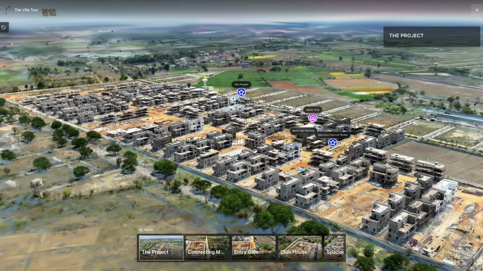
Aerial context can help a reviewer understand access, boundaries, and the relationship between work areas before moving into local detail.
For a large site, a map can be the first navigation layer. Open the public Vertex Tower map example to inspect browser wayfinding. It is a fictional presentation example, not a construction-progress case study.
Publish the right version to the right audience
Internal documentation and public progress marketing should be separate outputs. The internal edition may contain incomplete work, issue references, security information, people, plates, drawings, or commercially sensitive context. A public edition needs a dedicated review and should never inherit access merely because the internal viewer has a share button.
For every link, record:
- owner and intended audience;
- project, phase, and capture date;
- draft, reviewed, public, superseded, or archived status;
- review or expiry date;
- source and authoritative record locations;
- contact or takedown path.
Test the exact published link in a logged-out browser and on a phone. If an embed will be used in an owner portal or public update, test the embed itself rather than assuming the direct link is representative.
A simple progress review workflow
- Capture the approved route and record omissions.
- Upload and reconstruct the scene without deleting the source media.
- Check orientation, artifacts, privacy, and whether important areas are legible.
- Add stable stops and concise context tied to owned records.
- Review the audience and link status.
- Open the exact link on mobile and desktop outside the authoring session.
- Use the tour during the progress review.
- Record decisions in the project system and archive the edition correctly.
Common failure modes
- Changing the route so monthly scenes cannot be compared.
- Capturing active work without site and safety coordination.
- Presenting visual impressions as measurements or completion status.
- Overwriting old captures instead of preserving a dated sequence.
- Publishing faces, plates, screens, drawings, or restricted work.
- Leaving the only issue status inside a hotspot.
- Calling a viewer analytics event proof that a stakeholder understood or approved the work.
Frequently asked questions
Can Gaussian splats replace a construction site survey?
No. They are useful visual records, but accuracy depends on capture, reconstruction, control, and validation. Use approved surveying, inspection, and project-control systems for measurements, compliance, quantities, and contractual decisions.
Is 360 video or Gaussian splatting better for progress capture?
360 video is often easier to repeat along a fixed route. Gaussian splats provide freer movement and spatial context. A pilot should compare capture reliability, reconstruction quality, review usefulness, privacy workload, and mobile delivery on the actual site.
Should every progress capture be public?
No. Keep internal records separate from public communication. Review people, plates, drawings, screens, security details, safety conditions, and unfinished work before any public release.
Can Spatial Studio compare construction dates automatically?
Do not assume an automated change-detection or measurement workflow. Spatial Studio can publish clearly named, date-specific visual tours and stakeholder routes. Use dedicated project controls, inspection, and measured comparison tools for authoritative change analysis.
Next step
Pilot one route for four capture cycles. Keep the same names and review order, record every deviation, and ask the intended reviewer to find three known conditions without help. That will reveal whether the tour improves understanding before the workflow expands.
Use the broader Gaussian Splatting for AEC Field Guide to position the tour in the project stack, then review Gaussian Splat Hosting for access and delivery choices.
Next step
Generate a progress splat
Review a bounded recurring-capture pilot before you promise measurements, contractual evidence, or site-wide coverage.
Continue reading
Related articles
Commercial Use Cases
Gaussian Splatting for AEC: A Reality Capture Field Guide
Learn where Gaussian splatting fits in AEC reality capture, from recurring site documentation and remote review to BIM context and stakeholder tours.
Read articleCommercial Use Cases
3D Property Damage Documentation for Insurance and Restoration
Plan 3D property damage documentation for insurance and restoration using photos, 360 capture, Gaussian splats, guided review, and clear evidence boundaries.
Read article